
 Embankment view towards the island | around 1900


The Embankment
Monastery Malchow
Embankment
SHOW THE WHOLE TEXT
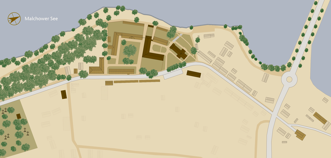
The embankment, or dam, is 250 meters long and connects the mainland on the monastery side with the island opposite, the old town of Malchow. In the Middle Ages, the island was connected to the eastern mainland on the southeast side by a “long bridge”. During the Thirty Years’ War it was severely damaged. In the subsequent First Northern War, the defeated Swedish troops moved through Malchow after the Battle of Fehrbellin (1675) and finally destroyed the bridge. It was never rebuilt.
A ferry was used to transport people and vehicles. The ferry house on the monastery side was demolished in 1982 because of a planned bridge construction to replace the earthen dam. The dam was mainly laid by the citizens of Malchow from 1844 to 1846 during the tenure of Mayor Friedrich Meyer and under the supervision of the state master builder of the Grand Duchy of Mecklenburg-Strelitz, Friedrich Wilhelm Buttel (under whose direction the earth dam in Vipperow was also built). When the earthen dam was laid, it was also built like a road, as was fashionable at the time. A sandy summer path ran alongside the paved road. The roadside was planted with staggered lime trees. The fixed connection between the island and the mainland was important for the economic development of the town of Malchow. The memorial stone in the middle of the dam commemorates the aforementioned mayor, Friedrich Meyer.
A toll was levied on non-resident pedestrians, carts and cattle transport for using the dam. The house of the dam toll collector, formerly the ferry house, was the house at Lange Straße 68, today’s restaurant “Don Camillo”. The toll was levied until 1888.
On May 2, 1945, the German Wehrmacht attempted to blow up the embankment to stop the Red Army from invading. Luckily the damage was minimal.
Between 2006 and 2007, the embankment was restored as an avenue and replanted with lime trees using historical designs.
Embankment
The embankment, or dam, is 250 meters long and connects the mainland on the monastery side with the island opposite, the old town of Malchow. In the Middle Ages, the island was connected to the eastern mainland on the southeast side by a “long bridge”. During the Thirty Years’ War it was severely damaged. In the subsequent First Northern War, the defeated Swedish troops moved through Malchow after the Battle of Fehrbellin (1675) and finally destroyed the bridge. It was never rebuilt.
SHOW THE WHOLE TEXT
A ferry was used to transport people and vehicles. The ferry house on the monastery side was demolished in 1982 because of a planned bridge construction to replace the earthen dam. The dam was mainly laid by the citizens of Malchow from 1844 to 1846 during the tenure of Mayor Friedrich Meyer and under the supervision of the state master builder of the Grand Duchy of Mecklenburg-Strelitz, Friedrich Wilhelm Buttel (under whose direction the earth dam in Vipperow was also built). When the earthen dam was laid, it was also built like a road, as was fashionable at the time. A sandy summer path ran alongside the paved road. The roadside was planted with staggered lime trees. The fixed connection between the island and the mainland was important for the economic development of the town of Malchow. The memorial stone in the middle of the dam commemorates the aforementioned mayor, Friedrich Meyer.
A toll was levied on non-resident pedestrians, carts and cattle transport for using the dam. The house of the dam toll collector, formerly the ferry house, was the house at Lange Straße 68, today’s restaurant “Don Camillo”. The toll was levied until 1888.
On May 2, 1945, the German Wehrmacht attempted to blow up the embankment to stop the Red Army from invading. Luckily the damage was minimal.
Between 2006 and 2007, the embankment was restored as an avenue and replanted with lime trees using historical designs.

Embankment

Laundry

Hospital

Smithy

Bulwark and Promenade

Church

Parsonage

Cloister Courtyard

Refectory

Dormitory

Deaconess's house

Wall Garden

Ladies' Retreat

Terraced Houses 1

Kitchen Master’s House

Terraced Houses 2

Administration Building

Jail

Barn terraced houses
and farm yard

Engels Garden

Monastery Cemetery

Cemetery Chapel

Burial Ground of the Conventual

Cartwright's Workshop

ALLE OBJEKTE ANZEIGEN
Embankment
Laundry
Hospital
Monastery Smithy
Bulwark and Promenade
Monastery Church
Parsonage
Cloister Courtyard
Refectory
Dormitory
Deaconess's house
Wall Garden
Ladies' Retreat
Terraced Houses | 1
The Kitchen Master’s House
Terraced Houses | 2
Administration Building
Jail
Terraced stable houses and farmyard
Engels Garden
Monastery Cemetery
Cemetery Chapel
Burial ground of the conventuals
Cartwright's Workshop