
 Engels Garden with Conventuals Garden (right) on a historical map | 1884


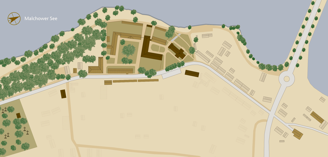
The Engels Garden
Malchow Monastery
Engels Garden
SHOW THE TEXT
In the 19th and early 20th century, the Engels Garten assumed the role of a monastery park. The formerly landscaped garden is now largely wooded. Today it adjoins a walled garden to the south-west, the so-called ladies’ garden, which was probably laid out in 1847. In the city plan of 1884, this walled garden is distinguished by a geometric network of paths.
The Engels Garden covers an area of 3.5 hectares. With its open spaces, trees and park walls it is a historically protected, listed monument.
A map from 1773 shows the monastery complex, but contains no reference to the Engels Garden. The terrain is presented in the same way as the surrounding agricultural areas. In 1792, the watermill, known as the monastery mill, and the windmill on the hillside south of the garden in the south-eastern adjacent lowland area were recorded. For many years they formed the predominant image of this lakeside area.
In the map from 1803, the “Engels Garden” appears for the first time in the sloped area south of the monastery. It was named after its creator, the kitchen master of the monastery, Johann Jacob Christian Engel (1762-1840). His active tenure was between 1786 and 1819. This garden, which was laid between 1787 and 1803, initially stretched behind the administration building, beginning around what later became the end of the monastery cemetery. It covered an area about a third as large as it is today. The directly adjoining area is called “Seikengrund”. A windmill is shown a little further south, at the highest point of the bank.
Friedrich Engel (1787-1857), the son of Johann Jacob Engel, became his father’s successor as kitchen master from 1819. During his tenure there was an expansion of the park. He also had the lime trees planted below the monastery buildings on the bank path.
In 1848, along with a regular path, wooded plantations and a roundabout are visible on the map. The path from the cemetery that intersects the axis at right angles is also drawn in as a visual axis. The expansion of the park reached roughly to the cut in the terrain with the long staircase.
A third section of the park was designed by the monastery’s official gardener Friedrich Schweideps (1826-1917) from the Seikengrund to the “beautiful outlook” and completed by 1856.
In the entire period between 1773 and 1884, the adjoining areas were used for agriculture, with the areas to the east of the garden being used mainly as arable land, and the lowlands to the south as grassland.
In the 19th century and at the beginning of the 20th century, the citizens of Malchow were allowed to use the monastery park for walks. However, the cutting of grass and herbs as well as “improper behavior” were forbidden. After 10 p.m., citizens were not allowed to be in the Engels Garden.
Garden – park – forest?
Old views and photos make it clear that the park appeared as a wooded area, especially on the hillside. On the other hand, the more plateau-like upper part and the lakeside area are clearly recognizable as landscaped areas due to regular planting. Photos, probably from around 1900, show new planting to supplement the avenue on the bank. This explains the quite different appearance of the avenue today.
The monastery’s historic park originally ended at the level of today’s buildings across from the park. A postcard from 1910 still shows the view from “the beautiful outlook” over the open landscape towards the brick factory.
The adjoining, newer, part of the park, now forested, includes the former site of the windmill and is bordered by a path to the subsequent lowland. As late as 1953 there was a large, teardrop-shaped clearing in the center of this reforested area. Created at the beginning of the 20th century, this area of the park has no elements or traces of design comparable to the aforementioned old area.
The eastern border of the park is formed by the road. Behind it is the area of the cemetery with its large stock of mostly aged lime trees. The main axis of the cemetery and a secondary axis of Engels Garden create a connection between the two green spaces across the street. In the axis from the chapel through the cemetery gate to the lake, an aisle can be seen among the plants. This had to be kept clear by frequently trimming and clearing the edge.
The park’s southern boundary is formed by a water-bound path that separates the park from the adjacent formerly wet grasslands and swamp forest. The old water mill is located on the adjacent site. The monastery’s mill stream once fed a large reservoir opposite the water mill, which was abandoned before 1953.
Those old maps which are still available contain only a few references to the complex and the further development of the garden. Historical map documents that relate specifically to Engels Garden have not yet been found. Written documents from the monastery showed that in 1852, an official order to maintain the park was issued. Regular care and maintenance was carried out up to the time of the Second World War. This practice was only partially resumed – if at all – after the end of the war.
The trees along the shore path today consist mainly of horse chestnuts, ashes, black alders, small-leaved lime trees, copper beeches and hornbeams. In the higher part of the park you can find some strong oaks, small-leaved limes, beech, elm and sycamore. The basic elements of the historic network of paths are still preserved, such as the central, long axis of paths up to the roundabout.
The long term goal is to maintain and continuously care for the Engels Garden, with the aim of curbing overgrowth, restoring paths to use and again making visual axes perceptible.
Engels Garden
In the 19th and early 20th century, the Engels Garten assumed the role of a monastery park. The formerly landscaped garden is now largely wooded. Today it adjoins a walled garden to the south-west, the so-called ladies’ garden, which was probably laid out in 1847. In the city plan of 1884, this walled garden is distinguished by a geometric network of paths.
SHOW THE WHOLE TEXT
The Engels Garden covers an area of 3.5 hectares. With its open spaces, trees and park walls it is a historically protected, listed monument.
A map from 1773 shows the monastery complex, but contains no reference to the Engels Garden. The terrain is presented in the same way as the surrounding agricultural areas. In 1792, the watermill, known as the monastery mill, and the windmill on the hillside south of the garden in the south-eastern adjacent lowland area were recorded. For many years they formed the predominant image of this lakeside area.
In the map from 1803, the “Engels Garden” appears for the first time in the sloped area south of the monastery. It was named after its creator, the kitchen master of the monastery, Johann Jacob Christian Engel (1762-1840). His active tenure was between 1786 and 1819. This garden, which was laid between 1787 and 1803, initially stretched behind the administration building, beginning around what later became the end of the monastery cemetery. It covered an area about a third as large as it is today. The directly adjoining area is called “Seikengrund”. A windmill is shown a little further south, at the highest point of the bank.
Friedrich Engel (1787-1857), the son of Johann Jacob Engel, became his father’s successor as kitchen master from 1819. During his tenure there was an expansion of the park. He also had the lime trees planted below the monastery buildings on the bank path.
In 1848, along with a regular path, wooded plantations and a roundabout are visible on the map. The path from the cemetery that intersects the axis at right angles is also drawn in as a visual axis. The expansion of the park reached roughly to the cut in the terrain with the long staircase.
A third section of the park was designed by the monastery’s official gardener Friedrich Schweideps (1826-1917) from the Seikengrund to the “beautiful outlook” and completed by 1856.
In the entire period between 1773 and 1884, the adjoining areas were used for agriculture, with the areas to the east of the garden being used mainly as arable land, and the lowlands to the south as grassland.
In the 19th century and at the beginning of the 20th century, the citizens of Malchow were allowed to use the monastery park for walks. However, the cutting of grass and herbs as well as “improper behavior” were forbidden. After 10 p.m., citizens were not allowed to be in the Engels Garden.
Garden – park – forest?
Old views and photos make it clear that the park appeared as a wooded area, especially on the hillside. On the other hand, the more plateau-like upper part and the lakeside area are clearly recognizable as landscaped areas due to regular planting. Photos, probably from around 1900, show new planting to supplement the avenue on the bank. This explains the quite different appearance of the avenue today.
The monastery’s historic park originally ended at the level of today’s buildings across from the park. A postcard from 1910 still shows the view from “the beautiful outlook” over the open landscape towards the brick factory.
The adjoining, newer, part of the park, now forested, includes the former site of the windmill and is bordered by a path to the subsequent lowland. As late as 1953 there was a large, teardrop-shaped clearing in the center of this reforested area. Created at the beginning of the 20th century, this area of the park has no elements or traces of design comparable to the aforementioned old area.
The eastern border of the park is formed by the road. Behind it is the area of the cemetery with its large stock of mostly aged lime trees. The main axis of the cemetery and a secondary axis of Engels Garden create a connection between the two green spaces across the street. In the axis from the chapel through the cemetery gate to the lake, an aisle can be seen among the plants. This had to be kept clear by frequently trimming and clearing the edge.
The park’s southern boundary is formed by a water-bound path that separates the park from the adjacent formerly wet grasslands and swamp forest. The old water mill is located on the adjacent site. The monastery’s mill stream once fed a large reservoir opposite the water mill, which was abandoned before 1953.
Those old maps which are still available contain only a few references to the complex and the further development of the garden. Historical map documents that relate specifically to Engels Garden have not yet been found. Written documents from the monastery showed that in 1852, an official order to maintain the park was issued. Regular care and maintenance was carried out up to the time of the Second World War. This practice was only partially resumed – if at all – after the end of the war.
The trees along the shore path today consist mainly of horse chestnuts, ashes, black alders, small-leaved lime trees, copper beeches and hornbeams. In the higher part of the park you can find some strong oaks, small-leaved limes, beech, elm and sycamore. The basic elements of the historic network of paths are still preserved, such as the central, long axis of paths up to the roundabout.
The long term goal is to maintain and continuously care for the Engels Garden, with the aim of curbing overgrowth, restoring paths to use and again making visual axes perceptible.

Embankment

Laundry

Hospital

Smithy

Bulwark and Promenade

Church

Parsonage

Cloister Courtyard

Refectory

Dormitory

Deaconess's house

Wall Garden

Ladies' Retreat

Terraced Houses 1

Kitchen Master’s House

Terraced Houses 2

Administration Building

Jail

Barn terraced houses
and farm yard

Engels Garden

Monastery Cemetery

Cemetery Chapel

Burial Ground of the Conventual

Cartwright's Workshop

SHOW ALL OBJECTS
Embankment
Laundry
Hospital
Monastery Smithy
Bulwark and Promenade
Monastery Church
Parsonage
Cloister Courtyard
Refectory
Dormitory
Deaconess's house
Wall Garden
Ladies' Retreat
Terraced Houses | 1
The Kitchen Master’s House
Terraced Houses | 2
Administration Building
Jail
Terraced stable houses and farmyard
Monastery Cemetery
Cemetery Chapel
Burial ground of the conventuals
Cartwright's Workshop